News Story
SCARE software predicts locations from observations and known constraints
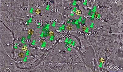
In this screen shot from the SCARE video demo, locations of church burglaries are indicated by green push pins. Yellow bullseyes are SCARE's predictions of the "partners" to these locations—the locations of the burglars' operating bases. SCARE also uses constraints such as the likely distance a burglar might travel to commit a crime in its calculations.
The abductive reasoning theory was developed by Subrahmanian; his Computer Science Ph.D. student, Army Captain Paulo Shakarian; and Professor Maria Luisa Sapino of the Università di Torino, Italy. Shakarian, who was twice deployed to Iraq, specialized in suppresing waves of roadside bomb attacks.
Abductive reasoning is a form of AI nonmonotonic reasoning for generating the best explanations for a set of observations. The theory models a scenario with two sets of locations (called “observations” and “partners”) that are related to each other based on a set of constraints. Based on the observations and constraints, the theory predicts the locations of the partners. In addition to military and law enforcement applications, potential uses include medical diagnosis, fault diagnosis, belief revision, modeling the behavior of large institutional investors and political organizations, database updates and automated planning.
The trio also developed Spatio-Cultural Abductive Reasoning Engine (SCARE) software, which uses abductive reasoning to resolve geospatial abduction problems. Currently, the military uses data from past insurgency attacks to predict “hot spots” where attacks are likely to occur in the future. SCARE’s techniques can extend this analysis to predict the locations of the weapons caches from which placers get their improvised explosive devices (IEDs). In a recent test, SCARE was used with promising success to predict the locations of IED caches in Baghdad and its Sadr City neighborhood, based on open-source data of past IED attacks. Using the geographic coordinates of attacks and arrested enemy personnel (the observations), along with known cultural and physical information (the constraints), SCARE predicted the locations of the “partnered” phenomena—the IED cache sites.
When the researchers compared SCARE’s predictions with reports of actual cache discoveries in Sadr City, they found that more than half were less than a third of a mile from real caches that had been discovered. In a real-life situation, military planners could use these predictions to help focus searches for caches within this most-likely area, saving resources, time, and ultimately lives.
SCARE works in conjunction with Google Earth and was recently demonstrated at the Third International Conference on Computational Cultural Dynamics (ICCCD) in December 2009.
Learn more about SCARE.
Main SCARE page on the UMIACS web site
Video demonstration of how SCARE can help pinpoint a burglar’s operations site
December 2009 Popular Science article
December 2009 Baltimore Sun article
December 2009 University of Maryland press release
Published January 6, 2010