[ Project 1 ] Low-Cost Swarm GPS
[ Project 2 ] Orbital Platform for Satellite Construction and Repair
[ Project 3 ] Intelligent Vehicle Platoons
[ Project 4 ] Smart Grid Optimization: Fault Circuit Indicators
[ Project 5 ] Quadrotor Mapping of 3D Spaces for Emergency Response
Title: Low-Cost Swarm GPS
Project Team: Christopher O'Hare and Kip Hart
Abstract: Present-day GPS satellite constellations consist of a small number of high-cost satellites. We propose a new GPS constellation concept consisting of large numbers of low-cost satellites. New innovations in miniaturization (ie: cubesats) allows for the creation of smaller high-performance satellites. This allows for the creation and launch of large numbers of small satellites for the same cost of a small number of larger satellites. A swarm of GPS satellites provides more accurate location information, minimizes signal loss due to weather patterns, and minimizes constellation performance degradation due to the loss of a satellite.
This project will perform a feasibility study of such a constellation. This will include analysis of optimal swarm size, orbit locations, and economics for both placement and maintenance.
Class Presentations: ... to be added soon ...
Final Projects: Scheduled for mid December
Title: Orbital Platform for Satellite Construction and Repair
Project Team: Jason Burr and Michael Cunningham
Abstract: We will develop an effective system to fabricate, repair, or modify satellites in orbit around the earth. For the purposes of this study we will be focusing on low earth orbits. In order to do this we will need to focus on two problems that can be independently optimized:
Both of these regions of interest will work independently and combine their optimized results to complete the total design. Results will serve as a feasibility study for the future implementation of satellites in the low earth orbit environment
Class Presentations: ... to be added soon ...
Final Projects: Scheduled for mid December
Title: Intelligent Vehicle Platoons
Project Team: Fanghua Qiao, Zbigniew Mokrzan, Arman Mousavi
Abstract: Vehicle platoons are implemented by designing a safe and efficient control system for cars to link and automatically follow a lead driver. This system, if integrated correctly within the preexisting infrastructure of highways, can lead to major advantages in terms of safety and efficiency on major highways.
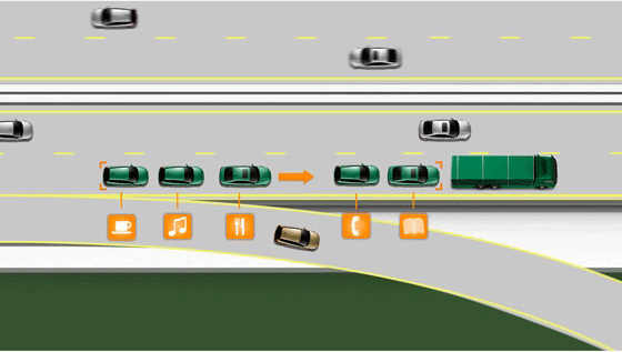
Fig. 1. Schematic for a platoon of vehicles.
Our goal will be to analyze the feasibility of such a system in the DC metro area, figure out how it will impact the daily commute, and detail the requirements with regard to control parameters, inter and intra-platoon communication, safety and costs.
General Background: Cars and buses in a platoon are allowed to maintain much smaller distances between themselves, which can greatly reduce congestion on major highways. Automated driving will also improve safety, as human error becomes a negligible factor and comfort. Moreover, platoons offer a much more relaxed user experience, as drivers have the ability to other tasks such as talking on a cell phone in the car.
Class Presentations: ... to be added soon ...
Final Projects: Scheduled for mid December
Title: Smart Grid Optimization: Fault Circuit Indicators
Project Team: Cheng-Ming Chow, Rebecca Baier, Michael Mera
Abstract: Power outages are an unfortunate reality of our electric distribution system but outage times can be reduced through a smart grid system which relays information to control personnel in real time. Our project aims to design one aspect of a smarter grid -- the addition of Fault Circuit Indicators (FCIs). FCIs reduce the time required to locate and repair faults and in some cases, faults can be prevented by using monitoring information from these sensors.
We will begin our design by considering the optimal number and placement of FCIs on one section of the grid called a feeder. A feeder encompasses the wires that deliver power from one substation transformer to its customers downstream. Feeders have several characteristics such as
Therefore, we will consider feeders with a range of these characteristics to determine which feeder characteristics yield the highest benefit with the addition of FCIs.
References:
Class Presentations: ... to be added soon ...
Final Projects: Scheduled for mid December
Title: Quadrotor Mapping of 3D Spaces for Emergency Response
Project Team: Matt Newman, Aaron Stehley, Sergei Drozdov
Abstract: The system's primary goal is to provide assistance in the case of an emergency. Our secondary goal is to provide an accurate mapping of a building's interior.
The mapping is going to be 3D and can be used for several applications. The map will be obtained as the system is being installed into the building and can be adjusted when renovations are made. The helicopters will have simple proximity sensors to avoid objects and find obstructions. They will also have infrared sensors that provide heat load mapping as well when they fly around. The data obtained by the sensor will be stored on a central server. The data could be used for several applications.
The building owner will be responsible for maintaining the quad rotors, 3D map, and the servers, they will also have ownership of the data. They can use the data however they seem fit, but several uses could be: planning renovations provide interior navigation maps and find heating and cooling problems. The secondary goal will be achieved by having the quad rotors use their own map to navigate through the building. The rotors will be illuminated with high power LED's that will be used to provide guidance for occupants on where to go to exit the building. There will be additional sensors in the copters that will report conditions to the servers to warn the quad-copters bout places of the building to avoid.
Class Presentations: ... to be added soon ...
Final Projects: Scheduled for mid December
Last Modified: October 11, 2012.
Copyright © 2012, Institute for Systems Research, University of Maryland